

This case study features Social Pinpoint’s legacy platform SPP Classic.
Background
The NSW (Australia) Government is developing a state-wide koala strategy, and has called on local communities to assist by documenting recent sightings, threats to koalas, ‘hot spots’ for road injury and conservation ideas. The strategy aims to stabilize and then start to increase koala numbers across the state.
Koalas are one of Australia’s native animals. According to Koala Express, there are only about 2,000 – 8,000 koalas left in the wild. Due to this devastating result, the NSW government is ready to take action. They want to identify a strategy with who handles each issue, the timeframe and funding needed to implement the new policy.
The government needs first-hand research to increase knowledge about koalas, their habitat, population trends and the threats causing koala numbers to drop. The strategy will also outline the information and tools necessary to assist the government, industries, community members and land holders to collaborate and take action.
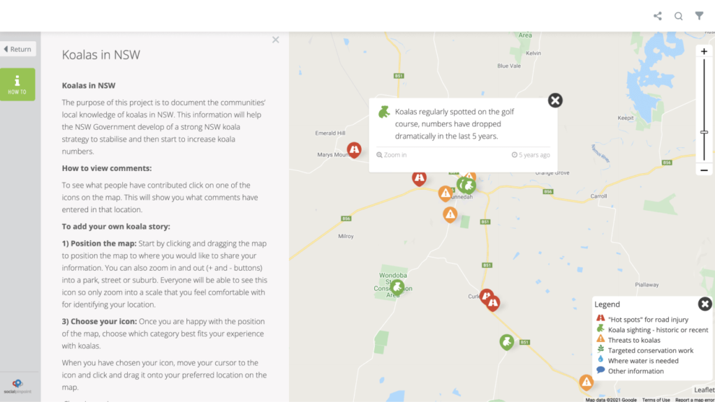
Outcome – It’s all in the Statistics
Social Pinpoint provided the Office of Environment and Heritage with an accessible and interactive way for the community, government, industries and land holders to interact with the project, and share their local koala experiences.
The project map included several marker categories that helped participants identify and report on their experiences – including ‘hot spots’ for road injury, koala sightings, local threats, conservation work and places where water is needed.
The Office of Environment and Heritage engaged Social Pinpoint to create outreach tool designed to:
- Create a transparent platform where anyone could share comments based on particular topics. Social Pinpoint created different marker types to represent the different issues. This made it simple to report on common issues and segment comments.
- Give participants the option of sending a confidential comment. Social Pinpoint allowed OEH to add an “additional” comment field. This meant when a participant wrote a comment, they could write an extra confidential comment to the site moderators. Social Pinpoint is also configured to keep all private information such as name, email address and post code confidential to reassure participants their information is secure.
- Allow the organization to monitor comments during the holiday period. Over the Christmas period, participants’ comments weren’t automatically posted to the Social Pinpoint site. Instead, the comment was reviewed before appearing on the Social Pinpoint map.
- Remove inappropriate comments. The profanity filter meant OEH could easily monitor comments and remove or mask any inappropriate comments.
To accompany the Social Pinpoint map, the project team also developed a project website with key information and opportunities to provide input, as well as hosting several information sessions and inviting written submissions.
Conclusion
The Office of Environment and Heritage needed a way to gather, track and report on issues affecting the NSW koala population. Social Pinpoint implemented an effective interactive mapping platform to help the organization collect the relevant local information that will help to shape the Koala preservation strategy.
Online interactive mapping software is a great tactic to use as part of a citizen participation strategy. Social Pinpoint’s online tools allow easy access for organizations to gather large amounts of information from stakeholder groups. The tool also allows for location-based mapping meaning the organization could refine the survey area to NSW.